Oregon FREE Camping-Boondocking in the Beaver State

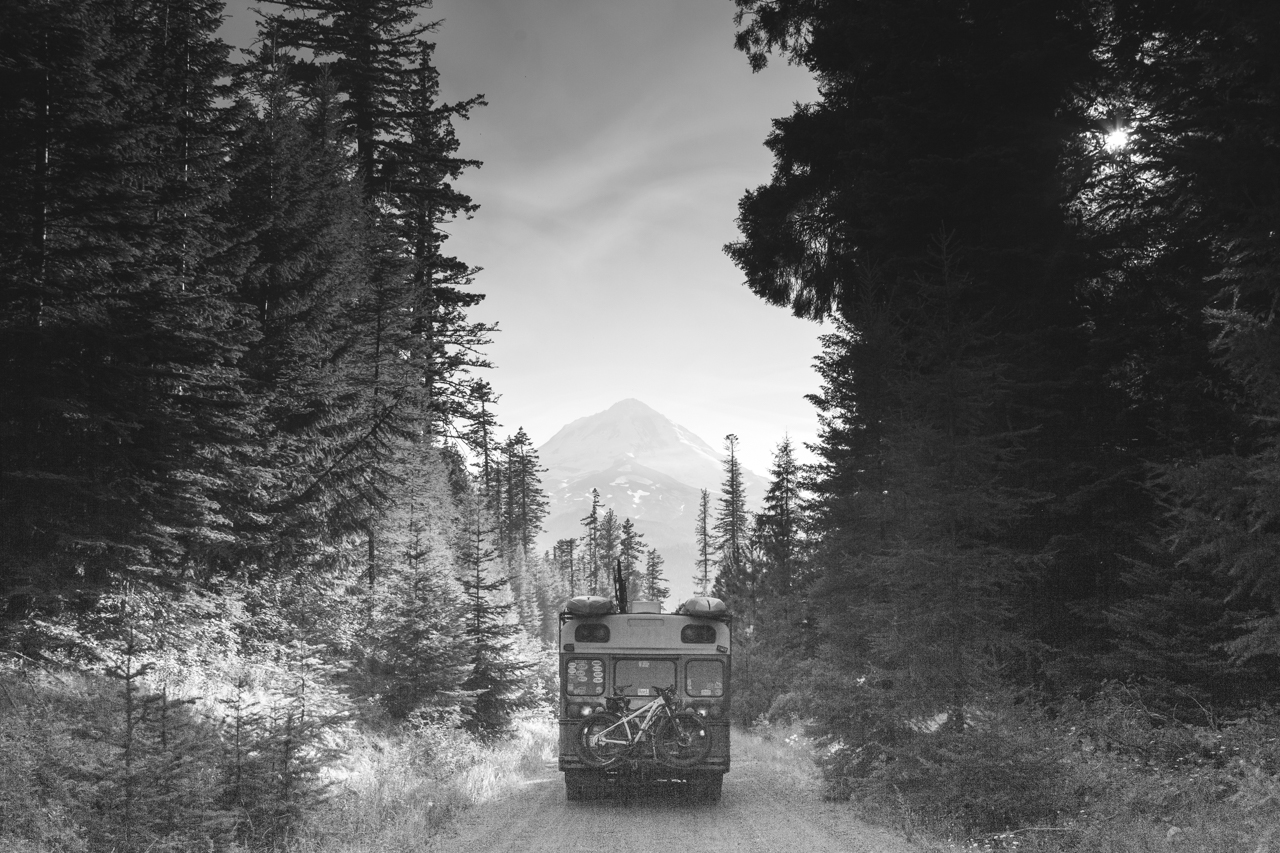
Free Camping in Oregon was as easy as we expected but not nearly as beautiful as we had thought. These campsites, however, allowed us to explore so many different parts of this amazing state without ever paying for a campsite. One thing to consider in Oregon is that the beach is public land, if you can get to it, it’s free game for boondocking. We are not equipped for driving through deep sand, so we avoided the beach. Your mileage may vary.

Coquille River Boat Launch

Bandon, OR

GPS: 43.163189, -124.362145

Nestled back in the corner of quiet Bandon, this boat launch parking lot is a perfect spot for a good night’s sleep and exceptional wildlife viewing. We were 1 of 3 rigs parked here on a Sunday night and all was quiet. A government research boat was parked there when we were and it looked to have been there a while. Seemed like a very safe and calm spot to boondock.

There are vault toilets and picnic tables near the launch and great access to the Coquille River a few miles before reaching the coast. We used this spot to investigate the nearby mountain bike trails close to Bandon.


Dorena Mining Camp

Dorena, OR

GPS: 43.627432, -122.703511

This little pull-out along a scenic back-road was a peaceful spot to relax and prepare for entering Eugene. Miners use this pull-out to pan and dredge for gold and black sand and have left several deep pools in the creek that are perfect for swimming.

Campsite on Arrival

The site was in poor condition when we arrived with shell casings and trash everywhere. We picked up and you should to. Trashing out such a beautiful area is really sad. We left it better than we found it as did the locals that hung out for a while.

Campsite at Departure


Phil’s Mountain Bike Paradise

Bend, OR

GPS: 43.970190, -121.513552

The heart of Bend’s Mountain Bike Mecca is the Phil’s System and there is Forest Service Camping all around the area! This spot was right off of the trail and really pleasant. This is a true boondocking spot with no services, but we really enjoyed getting to ride and explore this area.


Oakridge Green Waters Rest Stop

Oakridge, OR

GPS: 43.739128, -122.459006

This is a rest stop with flush toilets and river access. This lot is near the highway, but the noise wasn’t bad. The facilities were clean and this location is in close proximity to town and nearby mountain biking trails.

We tried several boondocking spots near Oakridge and got an uncomfortable vibe from most of the locations, near the railroad tracks. The rest stop was well lit and seemed much safer. There is a park adjacent that hosts music festivals in the Summer and Fall.


Evergreen Air & Space Museum

McMinniville, OR

GPS:  45.204028, -123.142602

Talk about a unique camping spot! Dry camping is offered for free in the back lot of the Evergreen Air & Space Museum. Parking is amongst airplanes and helicopters in a quiet corner of the property. Bathrooms are open during business hours and there are no facilities after the museum closes.


Hood River Dispersed Camping

Hood River, OR

GPS: 45.419751, -121.530729

Hood River is a treasure trove of dispersed camping! We found a spot out in the middle of nowhere and we really enjoyed our time there. It was quiet, wild, and fairly easy to get to.

Remember to Pack-it-in and Pack-it-out when wild camping in National Forests and insure that your campfires are fully out.


Lumber District Sand Dunes

Coos Bay, OR

GPS: 43.400069, -124.288338

This campsite is one of those instances where 4×4 and recovery equipment would have been ideal. The sand dunes near Coos Bay are beautiful and vast, plus entirely unreachable by our Skoolie. We camped at the trailhead and walked around the are. It was fairly quiet until the timber company down the block started work at 5:00AM.

There are no facilities here and it can get busy and full on the weekend. Some cars were left overnight with no problems. Much better and more affordable than the $75 KOA a few miles away.

Free Camping in the Sierras

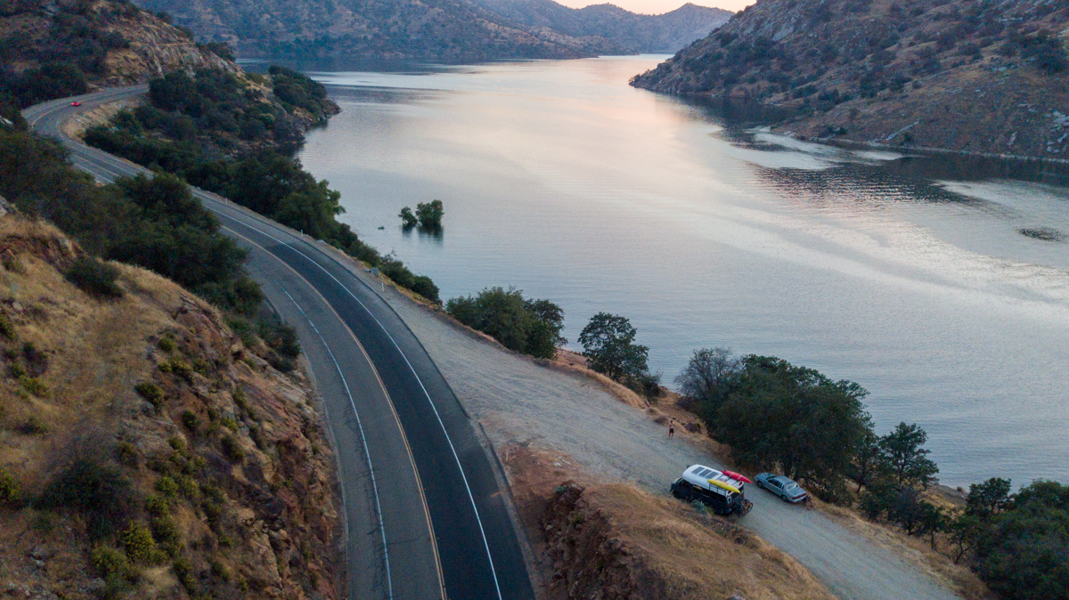
Remington Hot Springs

Lake Isabella, CA

GPS: 35.576386, -118.552872

Much like many of the sites we review, this is a parking lot. There are pull-outs all along this road, but this GPS point is a lot. It has excellent views of the Kern River below, and access to the Remington Hot Springs just down-hill.

The springs are nice and this spot is a great place to park to enjoy a late-night or early-morning soak.

Behind the Rock

Three Rivers, CA

GPS: 36.409936, -118.94564

This spot is exactly how the title sounds, behind the rock. There is a turnout at this GPS point that is behind a large mound of rocks that insulates the lake-side of the boulder from most of the road noise nearby.

There are toilets just down the road from this spot in the day-use area on the lake and the entrance to Sequoia National Park is only a short drive up the hill.


Stone Creek

Sequoia National Park

GPS: 36.663691, -118.846050

When exiting Sequoia National Park, you will pass Stone Creek Store and just after the store on the left you will see a Forest Service Road that is blocked with a tree. Next to the tree is a new trail/road leading back to several secluded spots.

This is a great spot to explore both National Parks nearby and a short hike North of here is a beautiful cascade waterfall. Animals walk through this area all day and don’t seem to mind people one bit.


Buck Rock Meadow

Kings Canyon National Park

GPS: 36.722725, -118.850537

There are pull-outs all down this road between Kings Canyon and Sequoia National Parks. Any sized rig can fit somewhere on this road. We found a spot right near a meadow a few miles down the road with a good view and level ground.


There were vault toilets near the beginning of the road and at both park visitor centers.


Bass Lake

Bass Lake, CA

GPS: 37.293835, -119.531886

Bass Lake is more of a stopover campsite instead of a “stay for a week” campsite. We stayed two nights and moved our rig during the day. The sheriff drove by at least once and waved, very friendly. We kayaked on the lake and explored the “town” before heading into Yosemite. Please don’t abuse this spot by having campfires, leaving trash, or being belligerent. This is a great rest stop before the National Park.

The nearby boat launch had bathrooms and potable water. The local authorities are very serious about collecting their day-use fees and were writing tickets during the week while we were there in the early summer. Tread lightly.

Miami Creek OHV Area

Fish Camp, CA

GPS: 37.415164, -119.636342

This is an OHV area and it appears that OHV drivers get to do whatever they want here. We stayed the evening up this road and only had a few rigs “BRRAAAAAPP” past us in the evening. The mosquitos were moderately aggressive, but the spot was level and relatively quiet.

Makes for a great basecamp for resupply in Oakhurst or traveling into Yosemite.

Goat Meadow Trailhead

Fish Camp, CA

GPS: 37.491268, -119.623491


This is a pretty straight forward parking lot and small wooded section nearby for dispersed camping. This is a simple lot with no amenities. Pack it in, pack it out.

Have you traveled frequently in this area and have a suggested spot? We would love to hear about it and potentially add it to our article. Email us at okienomads@gmail.com


FREE Camping in Southern California

We were pleasantly surprised to find more than enough FREE camping SoCal and we didn’t have to camp in a Wal-Mart parking lot! Below are some of our favorite sites from our time in Southern California.

Laguna Mountain

Julian, CA

GPS: 32.977978, -116.524818

We end up in trailhead parking lots a lot of the time because they are well-traveled, have access to trails, and normally have toilets. This spot was simple, had a great view of Anza Borrego in the distance, and was right on the Pacific Crest Trail.

There are quite a few level spots here and a vault toilet is available. Take a walk on the nearby Sunset Trail for beautiful views at the foot of the Sierras.


San Diego River Preserve

San Diego, CA

GPS: 32.76000856, -117.2250726

This site is a pull-out along the San Diego River in the heart of SD. There is bound to be a fair bit of traffic noise and potential conversations with homeless people living nearby, but you can’t beat the location for a quick night’s sleep and 5-minute drives to Sea World, Ocean Beach, and much more.

This can be an intimidating place to park, but we left our rig here for 4-5 hours at night and rode our bikes to Ocean Beach to have dinner and drinks and enjoy the ocean. There are plenty of runners and cyclists that use this abandoned road day and night, so we never felt unsafe here.


Law Street Beach

San Diego, CA

GPS: 32.8025916, -117.2595628

This section of curbside next to Pacific Beach is one of the best FREE camping spots we have ever had. The view of the Ocean is magnificent and the amount of active people around was very refreshing. There is not a lot of solitude here, but there is plenty of ocean to share.

This site had bathrooms and showers nearby and one only had to make sure not to park here during street sweeping, one day per week.


Thomas Mountain

Anza, CA

GPS: 33.5792566, -116.6241575

There are loads of pull outs and campsites along this OHV trail/road near Anza, CA. The road can be a bit rough and steep, so we stopped short of the top and had a great view of the valley below.

Vehicle with low-clearance should really try somewhere else, this road is rutted and rocky in places and could be hard to navigate in a rig larger than 24 feet.


North Joshua Tree BLM

Joshua Tree, CA

GPS: 34.172932, -116.224663

If you are looking for a peaceful escape from the modern world, this is not it. This is a dry creek bed that is used heavily for off-roading, dirt biking, and any other loud vehicle driving that you can think of. The lake bed is beautiful and very flat, but don’t plan on going to sleep until dark.

This is a perfect overnight spot before entering Joshua Tree National Park. The West Entrance is just minutes away and has a bathroom and brochure station for the park.


Sawtooth Canyon (New Jack City)

Barstow, CA

GPS: 34.670395, -116.98423

We recently (March 2020) added this campsite as we traveled to LA for work and this made a perfect stopover from Northern Arizona.

This campground is managed by the Bureau of Land Management and is very busy in the climbing season (October-March). There is a ton of climbing available in this area and something can be found for climbers of all skill levels. This site has toilets but they were full when we visited, there was also zero occupancy when we arrived on a Wednesday night in March-arrive early. All in all, it wasn’t a bad place to stopover on the way to LA. Be sure and hike to the top of the ridge and check out the views looking toward Big Bear.

We had some of our most unique campsites of our whole summer in So Cal and we think you will enjoy them too! Did we miss any spots along our route? E-mail us and let us know!

Top Free Camping in Arizona

We had a ball in Arizona! From backpacking in the Grand Canyon for 5 days to volunteering at a massively cool event (Overland Expo), to mountain biking amongst the ponderosa pines in Flagstaff, we had a blast. Flagstaff was one of the first towns in the West that we have visited that we both agreed could be a future “home base” for our adventures. The abundance of free camping is one of the reasons that we felt so comfortable with the area. Below are our picks for top camping spots in Arizona:

Nearby Grand Canyon National Park

Grand Canyon Forest Service Rd. 328

Tusayan, AZ

GPS: 35.98789, -112.12556

Don’t pay for camping in the National Park! This Forest Service road is just before the South entrance of Grand Canyon National Park and is an easy drive back into the woods. There are hundreds of spots on many different roads and plenty of firewood if the burn ban ever lets up.

With this much free camping available this close to the National Park there are bound to be some rude people that don’t appreciate free spots, but the farther back you go, the less you see them. We had two quiet nights here in late-April.

This camp site was a perfect staging site for our weeklong backpacking trip into the canyon. The National Park is only about 5-minutes away and the road in and out is extremely easy to drive.


Shultz Pass Road Campsite

Coconino Forest Service- Shultz Pass Rd. 553

Flagstaff, AZ

GPS: 35.355505, -111.589746

Visit the little-known National Monuments North of Flagstaff, AZ and enjoy free camping ACROSS THE STREET! We parked here and road out bikes to the Sunset Crater National Monument and it made for a good day. The park is super interesting and there are a ton of pullouts for all sizes of rigs and even tents.

Flagstaff is a dark sky city and the stars were amazing looking out toward the San Francisco Peaks. We really enjoyed the privacy and seclusion of this site compared to some others in Flag.


View from the hill above Oak Creek

Coconino Forest Service Rd. 535

Flagstaff, AZ

GPS: 35.045561, -111.754196

Looking for an escape from Flagstaff on your way to Sedona? This is the perfect stop for you. There are hundreds of spots along this forest service road that seems to go back forever. We camped at the top of the second hill and were very happy with our experience.

There were traces of elk all through our camp and a short hike up revealed a great view of the valley below leading to Sedona. Rigs of all sizes can find a spot here. The farther you drive away from the road, the better the spots get. Be sure and park at least 500 yards from the small pond near the road, this is a forestry pond for the elk population restoration efforts. They will ask you to move.


Walnut Canyon BLM

Flagstaff, AZ

GPS: 35.175436, -111.488306

If you are visiting the Walnut Canyon National Monument or are just getting into town on I-40 from the East, this is a good stop to prepare for a good time in Flagstaff. These spots are nothing special and most are just off of the dirt road, so during the day dust and noise can get a little rowdy. At night it was quiet and we slept well despite our proximity to the Interstate.

We saw several coyotes and birds and stayed here two nights. We would definitely stay here again.


Coconino Forest Service A-1 Mountain Rd.

Flagstaff, AZ

GPS: 35.201236, -111.738389

This road was packed with people camping during the week in May 2018. We simply kept driving until we found a spot. We had great views of the San Francisco Peaks and amazing stars at night. It was very quiet at night and the only complaint we had was some broken glass, which unfortunately is common on Forest Service roads.

Stars over the mountains

There are spots for rigs of all sizes and the road was in decent enough shape, with some wash board. We would definitely stay here again.


Coconino Forest Service- Snowbowl Road

Flagstaff, AZ

GPS: 35.292032, -111.677885

This is a rough road that is quite a distance from town. We are travelling in a 24-foot 2WD school bus and it took us roughly 45 minutes to make it from downtown Flagstaff to our campsite and we didn’t even drive to the deepest campsites. If you need to escape town for a bit, this site is perfect. It is near the ski area and the site was quiet and flat.

It seems that the 4WD roads go around the mountain in all directions as well as some very good mountain biking like Moto Trail and Shultz Creek Loop.


Welch Forest Service Road

Ash Fork, AZ

GPS: 35.217747, -112.377663

This campsite can be as adventurous as you are. There are a lot of spots for big rigs right off of the Interstate and you can explore deeper into the woods for a smaller, more private spot. Keep in mind that the southbound boundary that seems to connect on Google Maps, ends in a dead end and doesn’t connect to the Interstate. You want to exit the same place that you enter.

The road noise was minimal and there are plenty of level sites. Sheep are open-range farmed in this area, so be on the lookout for 1000 sheep that seem to go where they want.


Regardless of where you want to be in Arizona, our travels should give you a decent starting point for your adventures in Flagstaff and beyond. If you enjoyed this article, be sure to subscribe to our e-mail list on the right sidebar of this page; we don’t spam you, we just let you know when an article has published or when we have information we think you might want. As always, follow us on Facebook and Instagram and subscribe to our YouTube Channel…You’re the best!


FREE Camping in Southern Utah

Southern Utah Free Camping


Mexican Hat BLM
GPS: 37.172547, -109.847076

If you are leaving Moab, UT and looking for something fun and interesting to see in Southeast Utah, check out Mexican Hat, UT. Mexican Hat is named as such for the rock formation that hangs over the San Juan River near the Arizona border. The campsites are spread out, level, and right on the river! We camped here while we explored the Mexican Hat formation and nearby Monument Valley area.

Make sure that you fill up fuel and water on your way South and enjoy the peace, quiet, and epic stars that this site offers. There are a bunch of places to pull off and park near the rock formation but follow the road off the highway and stay left. Wind around the formation and park in one of the spots down by the river.

Leprechaun Canyon BLM
GPS: 38.017952, -110.536982

Utah is known for a few things; arches, Mormonism, and slot canyons. If you made it through Utah far enough to consider this campsite, you have encountered the first two in abundance. Slot canyons are often tricky to find and even more tricky to get all to yourself. However, there are some hidden gems that most tourists don’t know about and this campsite is one of them. There are a couple of parking spots in the parking lot up the road and two or three spots near this canyon at mile marker 28.1.

This campsite is nothing the shake a stick at and is very close to the road. However, the real beauty of this spot is the proximity to the Irish Canyons; a series of slot canyons right off of the road. We stayed here overnight after checking out the Ghost Marina of Hyte and spent all day exploring the canyons nearby. Big rigs will have a hard time with this spot and to access the 2-3 spots that are farther off the road you should have a 4×4 and traction devices.

Burr Trail Road GSENM
37.848739, -111.370629

This is more of a gravel parking lot than a campsite, but it gives a good starting point for exploring Grand Staircase Escalante National Monument and the town of Boulder, UT. Make sure to stop in the http://burrtrailoutpost.com and get a cup of coffee and a gluten-free sandwich before hitting the trail. The proprietor was very knowledgeable of the area and offers great advice on local trails and points of interest.

Casto Canyon BLM
37.784196, -112.331790

This road and subsequent pull-outs are located a few miles down the road from Bryce Canyon and have many of the same geological features that makes Bryce famous. Some spots are better than others, but the nearby Casto Canyon and Red Canyon Mountain Bike trails make this spot a solid starting point for an adventure in Bryce country.

There are vault toilets along the road at different campsites and there are spots for larger rigs along the road. Be wary of the higher elevation; in mid-April we pulled in with 65° temps and woke up the next morning with snow and temps in the 20’s. This is very common for the high desert, so be prepared with plenty of fuel, water, and food.

Bryce Canyon FS
37.665426, -112.182836


Just before you get to the welcome sign for Bryce Canyon National Park, turn right onto Forest Service Road 090 and enjoy the hundreds of campsites and pull-outs along the road. Free camping this close to a National Park where camping can cost $50+ is a lifesaver.

There was plenty of downed wood and the spot that we stayed in was very secluded and quiet. There were spots for rigs of all sizes, just make sure that your fire is put out and that you don’t mutilate the live trees that are everywhere.


LaVerkin BLM
37.170866, -113.249931

When you think about public land camping in the desert, this is what you picture. Beautiful views, clean campsites, and tons of mountain biking nearby. This was one of our favorite campsites in Utah and for good reason. The JEM mountain bike trail wraps its way around the butte and river below to form a network of trails for running or riding.

Cell service was excellent here as well. We stayed here while getting errands run in Hurricane and visiting nearby Zion National Park. If we make our way back to the Hurricane area again, we will definitely stay here. If you stay here, be sure to check out the Virgin River overlook and rim trail. It is worth the effort to get to it.

If you use any of these free campsites on public land, pick up after yourself. Please follow Leave No Trace guidelines and leave the land better than you found it. If you liked our content and want to see more of our travel and full-time bus living, check out our Facebook and Instagram pages and subscribe to our YouTube Channel.

SaveSave

SaveSave

SaveSave

SaveSave

SaveSave

Moab, UT- An Alien Planet of Adventure

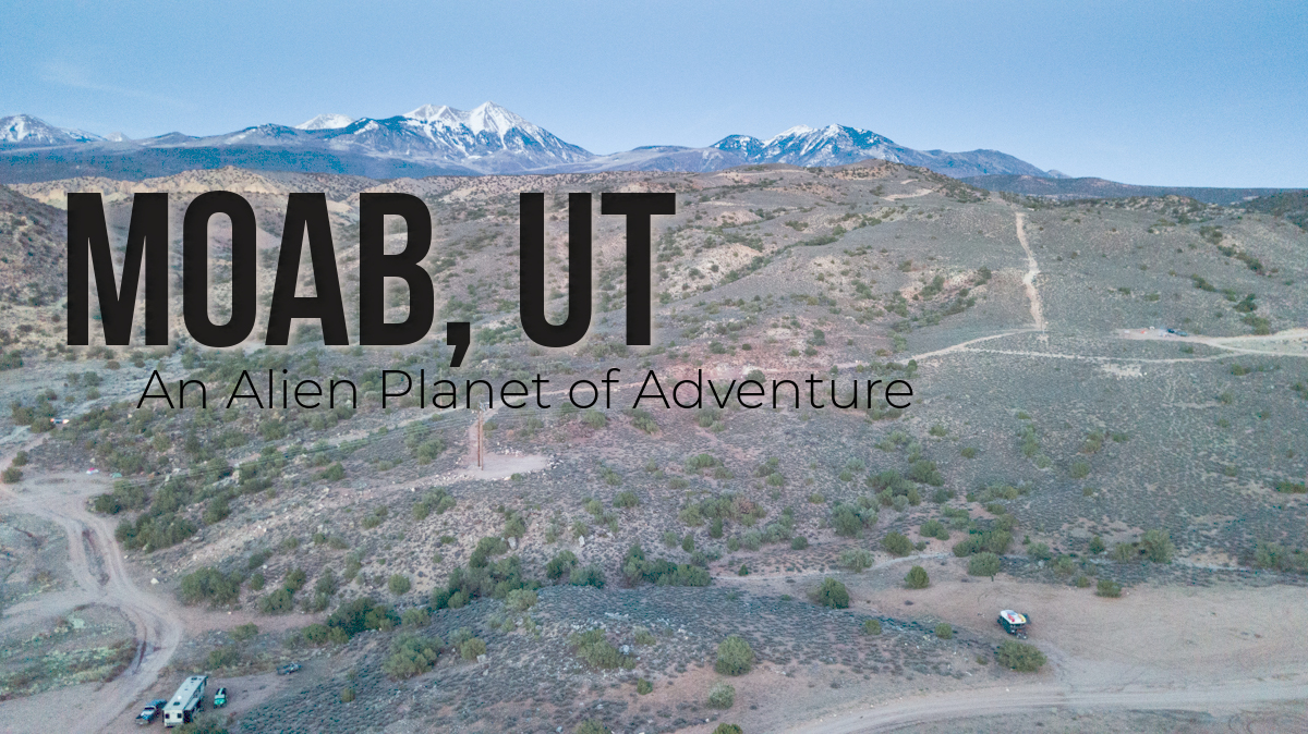
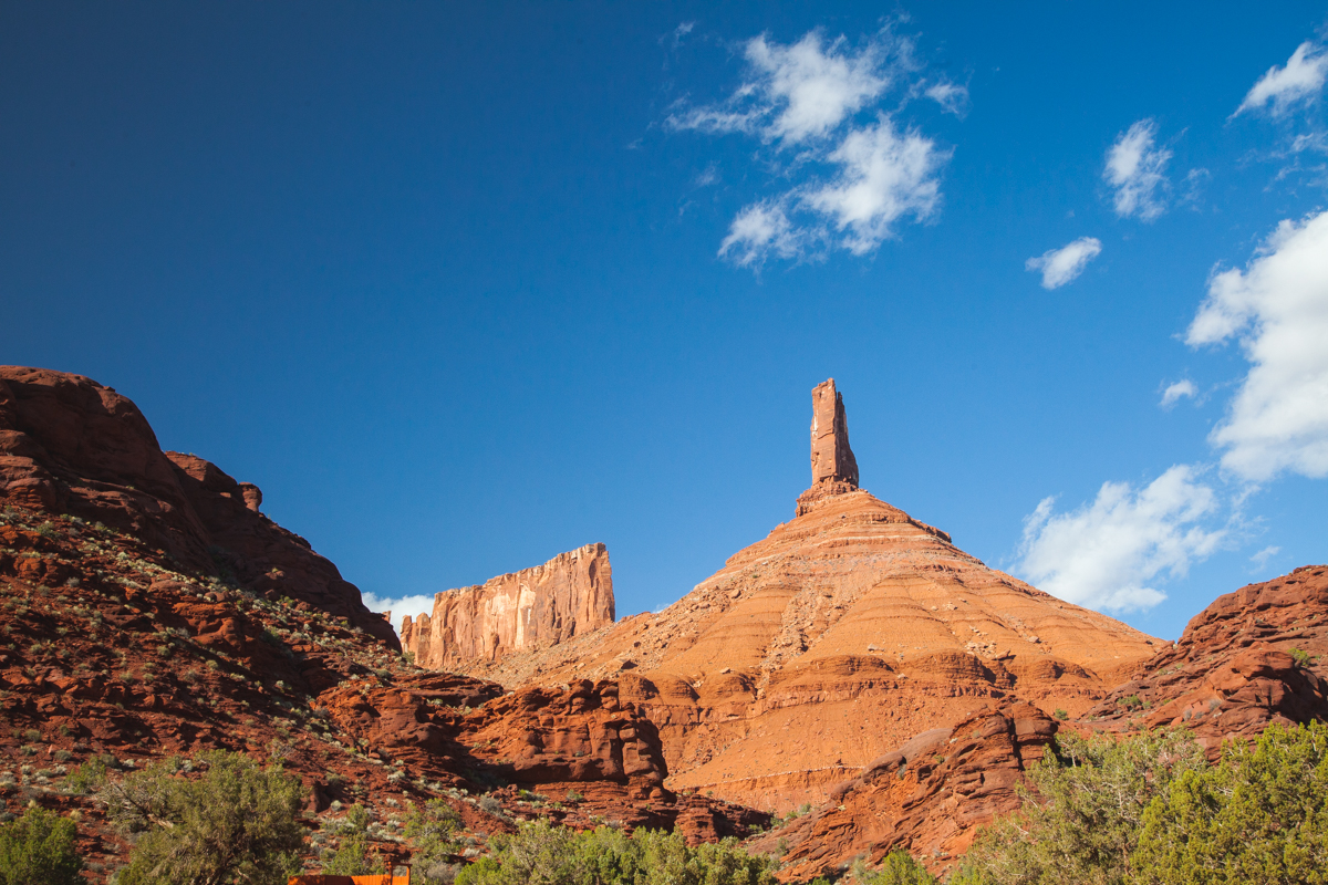
When you make the turn on HWY 191 to start the descent into Moab, Utah, you transition from a world of pine trees and alpine peaks to a landscape splattered with globs of slick-rock and arches that are a million years old: it’s like being on Mars. We spent a week in Moab and found it to be a very interesting little town, with just the right amount of quirk.

Camping

Moab is a free camping paradise! The entire town is surrounded by either Forest Service (FS) or Bureau of Land Management (BLM) land. Not to mention the fact that you could probably stealth camp on Main Street and no one would notice, or care. You can see all of the campsites we visited while in the Moab area, we have included GPS coordinates so you can find them on your next visit.

CAMPING IN MOAB

Considerations for boondocking in and around Moab: 

You can’t poop in the desert like you can in the woods

  • Due to the sensitive nature of the desert soil, defecating on the desert floor or even burying your poo is highly destructive to the environment. Bring along a portable toilet or use public facilities that are scattered all over town. Most campgrounds won’t allow you to stay unless you have a toilet set up.
  • It is a desert, bring plenty of water, sunscreen, and common sense

Seriously, temperatures can reach 100+ in the summer time and mixed with the dry heat can zap the energy right out of you. Remember to carry emergency water in your vehicle and always fill up at the visitor centers that offer free water. Below are a few of the free water locations we found in Moab:

  • 7-Eleven on Main St– FREE potable water to fill your RV or water jugs
  • Arches and Canyonlands National Park Visitors Center– The National Parks don’t want you falling out on the trail, use their water, you’ve paid for it already
  • Moab Visitors Center on Center St– The visitors center has every brochure and map       you could need to navigate Moab and they sell OHV permits for off-roading. Stop in and      ask the clerk about the guy from Louisiana with a strange accent.

Attractions/Activities

Moab is home to some of the most unique and beautiful landscapes in the world, most notably in Arches and Canyonlands National Parks. These national parks boast some of the most premiere arches and canyons in the World. The town supports world class mountain biking, hiking, and off-roading with a fine mix of culture and entertainment to go with it.

Arches National Park

Based on the name, you can guess what you will see at Arches National Park. Countless 300-million-year old arches abound in the park. These sandstone structures litter the horizon of this well-kept park. We became spoiled in Arches, because the road was just finished in the Fall of 2017 and is in excellent shape. On your way into the park, be sure and stop in the Visitor’s Center and fill up plenty of water bottles and jugs if you have them. You will be surprised at how much water you can drink in the desert.

The Windows Section of the park gives a warm-up hike to a set of arches that are all within a half-mile of the parking lot on easy trails. North Window, South Window, Turret, and Double Arch are well worth the short walk from the car.

Delicate Arch is the main attraction for park visitors and it seems the only way to secure a photo of the arch with no one in the middle of it, is to hike up in the early morning and secure a spot before the sun rises. We did not do that and wished we had. The trail to Delicate was littered with hundreds of people trying their best to climb the moderate slickrock trail. It was hard to be frustrated with the number of people, because at least they are outside taking their kids on a hike. The arch itself is beautiful and well worth the 3-mile roundtrip hike.

Devil’s Garden is the furthermost section of the park and it boasts the most remote trail in the Devil’s Garden Loop Trail. On this 7.2-mile loop, you will see Tunnel Arch and Pine Tree Arch, as well as Landscape Arch. Landscape Arch was especially impressive due to its 306-foot span and interesting history. In September 1991, a massive, several hundred-ton rock fall caused a section of the trail to be blocked off. Hikers were the witnesses to the rock fall and had to scramble to safety.

Canyonlands National Park

Canyonlands has a lot to offer both in Island in the Sky and the Needles District. The Island in the Sky offers views and trails from the top of the mesa, down. And the Needles District is known for its needle like features that grow out of the valley floor. The two districts are only 20 miles apart as the crow flies but take over an hour to drive between them.

We opted to stay in the park at the Willow Flat Campground. The campsites were super clean and much closer to the attractions in the park than they would be if we drove in from Moab. Just down the road from our site was the Green River Overlook which sports an amazing view of the Green River from a couple thousand feet up.

Rachael’s Pick in Moab

If you only get time for one stop in Canyonlands make it Mesa Arch. This is a very short hike from the parking lot, about 300 yards. The arch itself was not the grandest we saw, but the view behind the arch was spectacular! We got up just before the sunrise and biked to the trail. It was a cloudy morning, so the sunrise wasn’t awe-inspiring, but as the rays of the sun began to light up different parts of the canyon it seemed like every few minutes the view would change just a little bit. The distant horizon started as just a dark expanse but had so many shapes and colors as the sun brought it to life!

If you have enough time for a little bit longer of a hike take the two-mile round-trip hike out to Grandview Point. Island in the Sky gets its name because the park is on a big mesa. This hike takes you to the southernmost point of the mesa. As you walk out and look to the east there are several layers you will see below you. About 1,500 feet down is the White Rim. It is a layer of rock that looks white compared to all the red rock around you. On this layer there is a trail, the White Rim Trail (they thought really hard about the name), if you are lucky you will see either 4x4s or mountain bikers making the 100-mile trip around the mesa. As you look past the white rim and even further down you can see the Colorado River several thousand feet below you. As you approach the point look to the west and you will see the Green River. At the point you can almost see the confluence of the two rivers and you realize the shape of the mesa is formed by these two rivers.

Both hikes each had great features of their own, but the commonality of the two is the vastness of the views. It was amazing to realize just how far into the distance you could see.

Mountain Biking

If getting off of the road is your thing, then Moab is for you. Whether it is in a 4×4 or on a mountain bike, you can find a perfect trail system in Grand County. Because we live in a bus, we chose to hop on our Mountain Bikes and check out a couple of Trail Systems in the area.

Gemini Bridges

 This trail system has something for everyone. Easy, rolling blue/green runs or black diamond expert runs are available from most every trailhead. We chose to start at the top of the Mesa and ride the downhill first on the Getaway Trail. In hindsight, we would have started at the bottom and ridden up to enjoy the downhill on the way back to the trailhead. You are rewarded at the bottom with a short hike down to the Gemini Bridge which has formed over a stream and is a real sight to see.

Slickrock

The world-renowned trail at slickrock is world renowned because it is difficult. The entire trail is, you guessed it, slick rock. The terran is steep and you must have the appropriate gear and attitude to ride it successfully.

Bring the appropriate bike

It seems that the most successful of riders on Slickrock were on 27.5-29” full-suspension bikes, with flat peddles. Most had some sort of knee protection and had aired down their tires a bit.

Have a good attitude

If you never rode in Moab and you expect to fake it until you make it, you will be very frustrated at the experience. Come in willing to learn and willing to try a section a couple of times before you get it right.


Zach’s Pick in Moab

Klonzo

Klonzo has something for every skill level of rider, even specifically for young riders that are new to the sport. This park is located off of Willow Springs Road and is located on BLM land. The trails are well marked and well mapped. I really enjoyed the Wahoo and Vertigo lines on the North side of the road as they really pushed me and my riding ability. The trails combine slickrock and dirt singletrack as well as tough climbs and spirited downhill sections.

Start on the South side and warm up on Rollercoaster, then head over to try your hand at the more difficult but much more rewarding North side.

Food, Groceries, and Ammenities

We typically don’t eat out very much and Moab was no exception, the only place we visited in town for food was a coffee shop, Moab Roasters. The coffee was high quality and they sold pastries and gelato, but no gluten free food options. Other than the coffee shop we did not eat-out, so this review is really only for the grocery store. The City Market on Main Street had plenty of GF options and they were clearly marked with reasonable prices. If you are willing to cook your own food Moab can accommodate!

We did laundry at Moab Laundry Express and it was exceptional. The building was on a quiet street, the inside was clean, and the machines worked great. There are also 24-hour security cameras on the premises, which made us feel even better about the location. The next time we are in Moab, we will do laundry here again.

Moab, UT is such a unique and strange little town that everyone should come and see. Even if you aren’t a die-hard mountain biker or if you don’t like 4x4s, Moab has something to offer everyone. Come check it out before it gets too big and too developed to enjoy.

As always, you can keep up with our photographs and stories on Instagram and Facebook as well as our YouTube page. We hope you are enjoying this journey and we are glad you are following along.

FREE Camping in Moab, Utah

Below we have organized the campsites that we used while visiting the Moab, UT area and hope that you find them useful alternatives to paying high dollar for other spots in Moab.

Manti-La-Sal National Forest

GPS: 38.486044, -109.322178

This site ranks in the Top-10 campsites that I’ve ever stayed in. Thick pine forest, snowcapped alpine peaks in the distance, and a great view of the Moab area from around 8500 feet of elevation.

To get here you take the Manti-La-Sal Loop Road off of 191 and follow it around. It loops back to the Colorado River some 60 miles later. Only 15-20 miles from Moab, you enter the National Forest and begin seeing pullouts and campsites along the road. The site that we stayed in was a few hundred feet off the road and extremely flat and easy to get to.

The site is fairly short on downed wood so I would bring your own. Also, there is not a water source nearby, so pack in plenty of water. Don’t be the guy that cuts down green trees and leaves trash. Pack it in and pack it out.


Old Airport on 191 (Easter Time Frame ONLY)

GPS: 38.487989, -109.451691

This is a unique campsite as it is only available the week before and the week after Easter Weekend. These spots are intended for the influx of Jeeps that come into town for the Moab Jeep Safari on Easter Weekend. By the time we got there the following week, it was a ghost town. A few rigs stayed behind to ride some more trails, but there were hundreds of spots left. We camped on a nice level slab away from everyone else.

To get there, take 191 South out of town and turn at the Ken Lake turn. Once past the cement plant, continue straight instead of turning to Ken Lake. You will cross a cattle guard and have your pick of the lots.


Willow Flat Campground- Canyonlands National Park (Island in the Sky)

GPS: 38.384107, -109.888016

We typically don’t pay for camping. In this case, we did. We simply wanted to be closer to all of the attractions in Canyonlands National Park and we would have almost spent the $15 that it costs to camp, in fuel waiting to get in the park in the morning.

This campground is pristine. Even the vault toilets are the cleanest that I have seen. Each spot has a pull-in, fire ring, and pergola over a handicap accessible picnic table. The campground got very quiet around nightfall and was very calm all night.

It is a short walk (or drive) to the Green River Overlook and a short bike ride of car ride to a ton of the attractions in the park. These are first-come, first-served campsites and there are only 12, so get there before the 10AM checkout to stake your claim.


Willow Springs Rd. BLM

GPS: 38.695904, -109.681283

When people talk about free camping in Moab, they talk about BLM land on Willow Springs Rd. It is a little out of town (~15 minutes), but what you give up in convenience, you make up for in community and scenic beauty.

There are hundreds of spots along Willow Springs Road that can accommodate big rigs and small rigs alike. Get there early in the day and on a weekday if able to ensure that you get a good spot. When we were there in Early April, after Jeep Safari, there were hundreds of rigs scattered through the desert.

This spot has no facilities and you are required to have a portable toilet to camp there due to the sensitive nature of the desert soil. Be sure to pack out any trash or waste.

*The bonus to this site is its proximity to the Klonzo Mountain Bike Trail System. Klonzo is less than a mile down Willow Springs Road and was an absolute blast to ride.


Castleton Tower BLM-Castle Valley, UT

GPS: 38.642299, -109.376715

If your style is to get out of town and meet new people than the Castleton Tower BLM access point is a great choice near Moab. The Tower is popular with climbers, but there were plenty of non-climbers there as well.

The best way to get here is to take a day and drive the scenic La-Sal Loop Road from 191 in Moab and follow it 60-ish miles until it terminates in Castle Valley. You will see the campsite at the base of the tower. Another option is to take 128 out of Moab and turn South toward Castle Valley.

There are several tent sites scattered throughout the hillside below the tower, and enough parking for 10-12 normal sized rigs (sprinter van or smaller). There is a vault toilet, but as always, bring your own TP. This is a very popular climbing area, so be prepared for climbers to stumble into the site at any given point in the evening. It was a very quiet site with beautiful views of the stars.


Yellow Circle Rd. BLM

GPS: 38.426955, -109.419636

Similar to the spots on Willow Spings Rd., this location has a spot for everyone. It is the last left turn on 191 heading South out of Moab and the road climbs several different levels of camping. There are large spots at the bottom for big rigs and tent sites at the top, plus everything in between. The higher you drive, the more difficult the spots are to get to.

These spots boast great views of the La-Sal’s and of Moab. Like most areas in Moab, this is the desert and extreme caution should be had with the disposal of human waste.

That’s the list! We will be preparing one of these for each of the regions that we travel to as an aid to other travelers coming to  a new area. Let us know if we missed any good ones, we would love to add them to our list when we come back through town.

If you enjoyed our content, be sure and sign up for our e-mail subscription and subscribe on YouTube. We are also on Facebook and Instagram @okienomads.

FREE CAMPING: Carson National Forest- Tres Piedras, NM

GPS: 36.655331, -105.977997

We had planned on pushing through to Durango, CO and instead opted to stay near Taos, NM in the Carson National Forest. We found this campsite at www.freecampsites.net and it was spectacular.

We are big fans of boon-docking and not paying for a campsite, but we also want to be out and away from town and other people. This spot was perfect for that. The pine trees create a very secluded feeling even though you could be a couple hundred yards from another camper. There was one other camper there when we stayed in early April 2018 and it was quiet!

The best part about this spot was that the ambient light from Taos, NM doesn’t quite drown out the stars like it does down on the Mesa. The result is a beautiful show!


There is much to do in the Taos, NM area including mountain biking, river rafting, skiing/snowboarding in the winter. If you get the chance, check out the Rio Grand River Gorge Bridge near this campsite.

FREE CAMPING: Texas Travel Center- Amarillo, TX

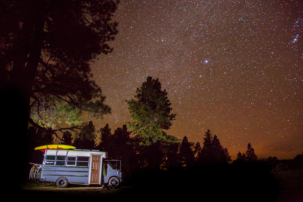
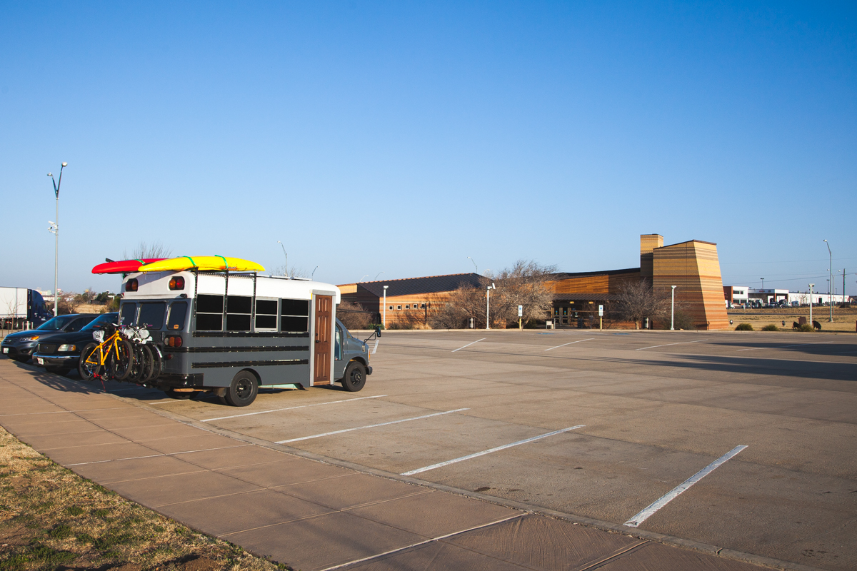
FREE Camping on I-40 near Amarillo, TX (EXIT 76)

GPS: 35.19151, -101.725334

In a previous post we showed you a wonderful little public park to camp in on the side of Interstate-40 if you don’t want to drive any farther. But what if you can’t make it to San Jon, NM? Stop in Amarillo!

*Previous Post: Free Camping- San Jon City Park

Right off of I-40 and near a Flying J truck stop is the Texas Travel Center. This property is paved, well lit, has 24-hour security, and was immaculately clean when we visited in April 2018. We arrived late and there were already several trucks, motorhomes, and passenger cars there. We pulled right in, used the facilities (which were spotless and warm) and slept soundly. The noise from 40 was not very noticeable, and this was one of our more enjoyable urban camping experiences.

We camped here in our skoolie conversion and felt right at home. If you are travelling along I-40 and can’t drive much long past Amarillo, consider this stop.

BONUS: The infamous Cadillac Ranch is nearby and is a must see if you’ve never been. These mid-century automobiles were erected in 1974 by the art group Ant Farm. Each caddy is arranged at an angle supposedly in line with the pyramids of Giza and is affixed in the ground nose down. The cars are now covered in graffiti and have been recovered and re-decorated for several PR campaigns in the area.

Cadillac Ranch is FREE and open 24/7 and is a unique piece of public art that everyone should see. Also, if you see my wife, ask her how she got purple hands and purple paint all over her jacket.

SaveSave

FREE Camping: Wapta Falls Recreation Site-Field, British Columbia

If you haven’t noticed yet, we don’t like paying for camping. We especially don’t like paying for camping when we are traveling through beautiful Western Canada and every dollar means we can stay on the road a little longer and see more of this beautiful country. Many thanks to the British Columbia Recreation Department for having so many awesome, free campsites and trails for public use. This one was located just down the road from Wapta Falls and offered amazing views of the falls and the mountains beyond.

How to Get There- (GPS: 51.109397, -116.500873)

Once you visit Jasper National Park, travel back down the Icefields Parkway and turn West on HWY 1 toward Field turn onto Beaverfoot Rd. Stay on Beaverfoot Rd for nearly 8 miles of rough logging road and turn left at the sign for Wapta Falls Recreation Site. The dirt road to the campsites is rutted and could be difficult to navigate in wet weather. We managed fine through a few puddles in a 19 ft. Class C RV. Getting out was a little tricky, but with some careful driving we made it out with no problem.

We pulled in at night and didn’t really understand how good of a FREE camping spot we had stumbled upon. Rachael started working on a delicious meal of red beans and rice and I took a walk outside to see what I could see, and hear. The sound of Wapta Falls 2000 feet below was LOUD! And if the stars could make noise they would have drown out the falls. This was by far the best night for night photography on our trip, but it didn’t last long. By the time Rachael got done with dinner, most of the stars had hidden themselves behind cloud cover.

We rested easy knowing that the parking brake was on and that we would awake to the sound of a mountain waterfall and what was sure to be a beautiful view. We slept in the next morning and awoke to great conditions and undoubtedly one of the best views of the trip. Chancellor Peak and Mt. Vaux dominate the horizon and Wapta Falls, massive in its own right, is dwarfed by the peaks above. It is crazy to think that only a day before we were hiking to the abandoned campground and the hoodoos at the base of Chancellor Peak and now we were viewing the same peak from a great distance.

You could say that there were facilities here. There were a couple of fire pit areas and a couple of picnic tables that seemed to be pretty well maintained. There was also a pit toilet between the campsites that seemed to be in okay shape. We would definitely poop here again.

Activities in the Area

  • Wapta Falls Hike-The most obvious activity in the immediate area is to hike to Wapta Falls. The falls are beautiful and huge. There are two options to hike to the falls from this campsite. One is to drive Beaverfoot Rd back to HWY 1 and turn West until you see the sign for Wapta Falls on your right. The second option (we suggest this one) is to hike down and bushwhack your way from the campsite to the falls. It is a lot of elevation to climb back up, but we think the views will more than make up for it.
  • Golden, BC- This quiet little town was one of our favorites from the trip mostly because of the quaint size and the amenities that abounded for such a small town. Our favorite stop in Golden was Bacchus Books. This bookstore doubles as a cafe and coffee shop. The selection of books was impressive considering the whole place couldn’t have been 2000 square feet on both floors. We enjoyed the baked goods and reading in a coffee shop that wasn’t packed full of people.

It really was a shame that we had to leave this campsite so soon, but we had more to see in Yoho and time was starting to run out on our Canadian adventure. We hope that you enjoyed our review of this campsite and hope that you continue to follow our adventures on YouTube, Instagram and Facebook as @okienomads.

error

Enjoy our content? Help spread the word! ;)

Follow by Email
YouTube
YouTube
Instagram